
Understanding Property Survey Regulations in Utah
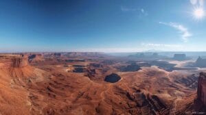
Learn essential property survey regulations in Utah to ensure compliance. Understanding these rules is crucial for property owners and developers alike.
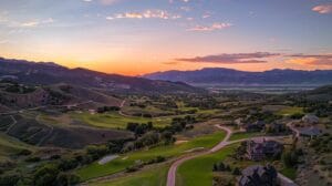
Get accurate and reliable land surveying services for your Utah project. Enhance your planning and development with expert insights tailored to your needs.
Get expert land surveyors to resolve boundary disputes efficiently. Trust our skilled team to ensure accurate solutions for your land challenges today!
Unlock precise property survey solutions in Utah today! Our expert land surveyors offer reliable services tailored to your needs for successful projects.
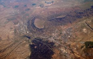
Mapping all city streets, subdivisions, city lots, major features, and city utilities Anderson Engineering completed a GIS mapping of the city of Grants, NM. The
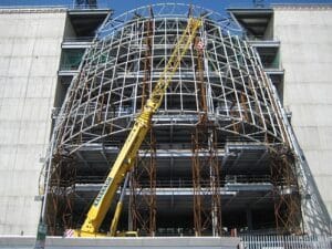
21,000 seat auditorium, 1.2 million square feet The Church of Jesus Christ of Latter-day Saints Conference Center is considered as an architectural miracle by many
Quickly resolve property disputes with expert land surveyors. Our professional team provides accurate assessments to clarify boundaries and protect your rights.
Unlock Business Success: Master Zoning Laws for Commercial Development. Expert guidance in navigating zoning ordinances for your thriving enterprise awaits you!
Enhance Property Value: Optimize Fence Location with Expert Property Surveys
Anderson Engineering: Your Partner in Precision and Efficiency In the world of construction and land development, accurate data is paramount. Every project, from a simple
```
Land surveying is a critical process that involves measuring and mapping the earth's surface. It employs various techniques to determine land boundaries, elevations, and dimensions, ensuring accuracy in construction and real estate transactions. Different types of surveys, such as boundary, topographic, and hydrographic surveys, each serve specific purposes and require unique methodologies.
Modern land surveying increasingly relies on advanced technology, including GPS and digital photogrammetry, to enhance precision and efficiency. These tools allow surveyors to gather data quickly and reduce human error, making it easier to create comprehensive topographical maps. Understanding these techniques is essential for both professionals and clients, as they significantly impact project planning and execution.
Engaging a professional land surveyor offers numerous advantages that contribute to the success of any project involving land. Professional surveyors bring specialized knowledge and skill that ensure the accuracy of measurements and the reliability of land data. This expertise helps in avoiding potential disputes with neighbors and minimizing risks associated with zoning and legal issues.
Additionally, professional land surveying can save time and money in the long run. By accurately identifying property boundaries and potential restrictions, landowners can make informed decisions about land use and development. Ultimately, a professional survey can streamline the construction process and provide peace of mind for clients, knowing their projects are built on solid legal ground.
Selecting the right land surveyor is crucial for any project, as this decision can significantly influence the project's overall outcome. It is important to consider factors such as licensing, experience, and the range of services offered. A qualified surveyor should have relevant certifications and a proven track record in handling projects similar to yours.
Moreover, communication is key when working with a land surveyor. Clear dialogue regarding project expectations, timelines, and budget will ensure that both parties are aligned. Prospective clients should feel comfortable asking questions and discussing their needs, as a good surveyor will be proactive in addressing concerns and providing guidance throughout the surveying process.